Pages

Year in Review

A la niña winter. A warm, rain-ridden spring followed by late season snow storms. A cool summer and a high alpine backpacking season frequently thwarted by the lingering snowpack. Snowshoeing. New solo hikes. Blisters. Yellowstone. Spain. Bike wrecks & getting chased by geese. Although recently I haven't been out as much as I would have liked (due to this little thing called SKOOL), t'was a good year.

This is mostly just a trail summary, with some of my favorite pictures from last year.

JANUARY
Tamanawas Falls snowshoe, Mt. Hood Wilderness: ~4.5 miles, ~500 ft elevation change.

frozen Tamanawas Falls

Boundary Trail, MSH National Monument: ~6 miles, ~1000 ft elevation change.
Coyote Wall, Columbia River Gorge: ~12 miles, ~1950 ft elevation change.
Eagle Creek, Columbia River Gorge: ~9 miles, ~600 ft elevation change.

FEBRUARY  
We spent February 13th-18th in Yellowstone National Park. It's one of the best trips I have ever taken.

MARCH
Hummocks/Boundary Trail snowshoe, MSH National Monument: ~5.5 miles, ~1200 ft elevation change.

Helens' winter coat


APRIL
Swale Canyon, Klickitat Trail, Washington: ~6.5 miles, ~200 ft elevation change.
Multnomah-Franklin Ridge Loop, Columbia River Gorge: ~12 miles, ~2650 ft elevation change.
Dog Mountain, Columbia River Gorge: ~7.5 miles, ~2820 ft elevation change.

MAY
Hamilton Mountain, Columbia River Gorge: ~8 miles, ~2100 ft elevation change.

Hamilton & the Gorge

Ruckle Creek Trail, Columbia River Gorge: ~7 miles, ~2660 ft elevation change.

JUNE
Swift Creek Trail, MSH National Monument: ~4.5 miles, ~1000 ft elevation change.

JULY
Burnt Lake Trail, Mt. Hood Wilderness: ~6.8 miles, ~1500 ft elevation change.
Grassy Knoll,Wind River Recreation Area: ~4.4 miles, ~1200 ft elevation change.
Mount Saint Helens Climb: 12 miles, 5600 ft elevation change.

Worm Flows climbing route

Little Baldy, Silver Star Scenic Area: ~8.4 miles, ~1600 ft elevation change. 
Ed's Trail, Silver Star Scenic Area: ~5.5 miles, ~1400 ft elevation change.

AUGUST
Cooper Spur, Mt. Hood Wilderness: ~8 miles, ~2800 ft elevation change. 
Goat Lake backpack, Goat Rocks Wilderness, Washington: 13 miles roundtrip, ~1770 ft elevation gain

moonrise over Ives Peak & Old Snowy
Wallace Falls State Park, Washington: 5.5 miles, 1200 ft elevation gain

SEPTEMBER
Santiam Pass-Canyon Creek Meadows-PCT Loop, Mt. Jefferson Wilderness: ~25 miles, no idea. 
Zig Zag Canyon Overlook, Mt. Hood: ~5 miles, no idea.
Paradise Park, Mt. Hood Wilderness: ~12.3 miles, 2300 ft elevation gain

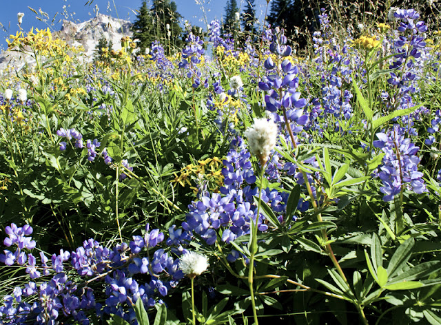
flowers galore in Paradise


OCTOBER
Ingalls Lake backpack, Alpine Lakes Wilderness: ~10 miles, 2500 ft elevation change


Butte Camp Trail, MSH National Monument: ~8.5 miles, ~1700 ft elevation gain

NOVEMBER
(Nothing but project, project, paper, paper, exam, exam.)

DECEMBER
Coyote Canyon Trail, Columbia River Gorge: ~6ish miles? elevation gain unknown
Larch Mountain Trail, Columbia River Gorge: ~8 miles, ~2800 feet elevation gain

~220.3 miles, ~40,400 feet elevation gain. 
Hide and Seek


COYOTE CANYON TRAIL
Columbia River Gorge National Scenic Area, Washington
~6ish miles?

The Coyote Wall is a relatively new trail complex on the Washington side of the gorge, just past Hood River. The giant basalt cliff lies in that fascinating transition zone between the stormy, damp western half of the gorge and its drier, golden-hued, eastern counterpart. From I-84, the Coyote Wall looks to plunge on a long, angled slide into the Columbia River; it never fails to grab my attention on any drive through the gorge. Until recently, the area was private range property which is now quickly turning into a mountain biking mecca. 

the cattle chute

Hikers are welcome here, but make no mistake, the trail complex here was built for and is maintained by cyclists. Watch uphill and be polite- hikers are the guests here.

That said, cycling trails completely screw with any hiker sense of direction I might have. Rocky and I set off mid-morning to attempt the Coyote Wall (short) loop in reverse, heading up the Coyote Canyon trail, the wall still visible from the lower part of the trail but disappearing into thick fog higher up. My dog took off, a joyous, bounding, deer-colored streak zooming along S-curves and soft dirt built for mountain biking whoop-de-whoops which made no sense to my hiker legs. Still, it was a gorgeous, winter hike through bare-branched oak forest, the meadows littered with umber colored leaves, silver-green moss clinging to any surface allowing it to thrive. 

a little mountain biker boulder garden

This was my third visit to the Coyote Wall complex, and it is officially one of my beloved winter/early season hikes. A good friend and I first visited in April 2010: we were greeted by an explosion of balsam root and lupine flowers, and we also got very lost, accidently ending up on private property while attempting to navigate the complex of trails and roads still left over in the area. Since we didn't have any wine or cheese, back the way we came.

Bring wine & cheese next time
 
My second visit consisted of myself, Andy and two dear friends attempting to complete the Coyote Wall (long) loop in typical January conditions.  We traipsed along the narrow, narrow, narrow Crybaby Trail, the cliffs spooky and beautiful in dense fog. During this trip I noticed the Wizard Trail junction plunging down the wall and filed it away in my mental hiking rolodex for future reference. We made it down a private road to what we *thought* was our trail junction but ended up far north and west of the wall when we finally popped out of the woods. Whoopsies. From there, it was cross-country and down and to an angle to find our way back to the trailhead. 

Not for crybabies
I'm not sure why I chose to begin the loop clockwise instead of counterclockwise in terrain I already knew. Probably had something to do with Rocky bounding off like a crack head just past the cattle gate. Decision made. Regardless, as I progressed higher up the trail into thick, dense fog, I couldn't help but admire the trail from a two-wheel point of view. Make no mistake, I am NO mountain biker- I'm more likely to run headfirst into a tree than make it downhill intact. Still, if I were more talented, I might consider it: this single track looked like a helluva lot of fun.
 
Approximately two miles from the cattle gate, I found the nearly invisible-to-spot junction with the Wizard Trail. I turned right and soon stumbled across a second junction I had not read about. Hmmmm. One fork was marked with blue flagging but looked less used, the other fork was more distinct, but unflagged.  

Just to completely screw with any iron I might have in my nose, the entire forest was shrouded in one of the densest layers of fog I have ever hiked in. I knew the Coyote Wall was looming almost directly in front of me and that I needed to be climbing up it, but I couldn't see it. There was absolutely no sense of direction. I wandered around both forks for a while before eventually deciding to head up the left (unflagged) fork. Here it was clear the trail sees little to no use, no evidence of hiking boots or bike wheels marred the thick layer of oak leaves. And again, biking trails make no sense for hiking legs- the little loop-de-loops and whoop-de-whoops make the trail feel like it is consistently going the wrong direction. 


Poor planning on my part. Oh well. With no map and no printed trail directions with me, I chose instead  to just wander through the glorious, fog-shrouded woods for a while. Eventually I happened upon a section of trail that looked like I might actually be on the right path, and proceeded to almost immediately lose the trail in wet meadow and fog. Hmmmm. I perched atop a rock for a while, watching mist play between tree branches, and surprised myself by feeling very much a child again. My agenda for the day had failed, but I had found an unexpected and coveted space of emotion: I felt secretive, hidden, lost in the woods, queen of my own domain. There was no one else around. 


Eventually I returned the way I came, and upon further analysis at home, determined I was most likely on the right track up the Coyote Wall. I was headed in a northwest direction, navigating the base of the wall (or where I *think* it was), and I passed a few signature, downed trees written about in the trail description. My expectations of what the trail should look like from a hiker point of view confused my sense of direction, but when I think about it, the trail would wander (seemingly aimless) as it slowly climbed higher along the wall. After all, what is fun for cyclists and what makes sense for hikers are two very different things.

Still, it's a brilliant area. And one that always plays hide and seek with my sense of self.

Larch Mountain Fail


Question: When do paved, interpretive trails and gorgeous waterfalls NOT mix?

Answer: Anytime the weather turns below freezing for extended periods of time. All that glorious waterfall spray? Yup, turns the path into a skating rink.


LARCH MOUNTAIN TRAIL
Columbia River Gorge National Scenic Area, Oregon
~8 miles, ~2800 feet elevation gain

I had just crossed the Multnomah Falls bridge viewpoint when I was abruptly halted by a layer of solid ice, about an half inch thick. A nice gentleman just in front of me was carefully shuffling his way up the path, tossing a layer of gravel across the ice as he went. Rather than skidding out over the next 100 feet of trail, Rocky and I waited patiently behind him for the task to be complete.


My goal today was Larch Mountain, a long, forested , straight-shot hike to the top of gorge from Multnomah Falls. Being midweek and 32 degrees at the trailhead, it made sense that I was alone- still, it's very, very odd to be heading up the Multnomah Falls trail without a soul in sight.

I love the gorge in winter. There is a remarkably stark yet vibrant quality to the area- looming cliffs shrouded in fog, silhouetted trees in the forest, the details whittled down to green mosses, ferns, rock and water, all the chaos of summer foliage gone. I rarely visit the gorge in summer: too many tourists. But in winter? This is when, for me, the gorge comes to life. 


That said, trail maintenance is zero in the winter. Mud is expected, as are slick conditions and downed trees. Given the recently dry (but oh so cold) spell holding on to the greater Portland area, the trail was remarkably ice free in areas where I expected slick conditions, and an icy wonderland in sections I would not have expected. The tiny, frozen details were enchanting.

About four miles in, growling and annoyed, I stopped to take stock of myself. I was a little over halfway to Larch when I knew I had a problem. Although I had been hiking uphill for roughly two hours and should have been in full throttle, hiking swing, my core temperature was dropping rapidly. It felt like I was fighting every muscle in my body to continue up the trail; I was feeling ill and stiff, sweat-drenched and lethargic, and I was beyond shivering even. Not a good sign.

Grrrr.

I drank some warm tea, re-layered clothing, and finally gave up on eating as I just couldn't stomach it. In the end, I made the decision to turn around. Over the last couple of months, I have had a brilliant professor who has repeatedly encouraged us to notice what is in our bodies and to ask clients to do the same. Noticing the details of how you feel, where you are in space- mentally, emotionally, physically- are a vital component to delivering care. Today, in below freezing temperatures, four miles from the trailhead with three more to go, it was better to be safe and listen to what my body was telling me. 


I took my time going downhill. I stopped frequently, drank warm tea, evaluated Rocky's feet, and took in the details of the forest. Now that I wasn't racing daylight, I stopped to soak in the minutia that calls attention to itself when we stop rushing and just take the time to be. Although the day wasn't what I planned it to be, it was, nevertheless, not a loss. 

I love winter. 


Cabin Fever


BUTTE CAMP TRAIL
Mount Saint Helens National Monument, Washington
~8.5 miles, ~1700 feet elevation gain

Toaster crumbies: the little, black, crusty, desiccated residual leftovers at the bottom of the toaster oven. Sometimes still slightly gelatinous, always gross, and never resembling the previous life form that was burnt to a crisp at the bottom of the oven. 

Midterms just passed, including the pathophysiology test from hell. I love school. But right now, I am mental toaster crumbies. And grouchy. Andy, too, has a major case of cabin fever. Time for a hike.

We decided to try a previously thwarted hike attempt on Mount Saint Helens from Butte Camp Trail to the Loowit Trail. The hope was to find some elk to stalk; whether we would find any remained to be seen. But it was time to enjoy the remaining vestiges of fall before winter settles over the high country.

There is something about Helens during the cusp seasons. During high summer she is naked and dusty, pumice-strewn, hot, treeless. Heather and lupine abound, but there is a quality and beauty to the area that calls to both Andy and me during the quiet, muted seasons of fall and winter. The tortured landscapes around the mountain grow calmer in the subtle colors of winter, softer under their blanket of snow. During fall, a brief explosion of color among the huckleberries and grasses lines the mountain in brilliant reds, oranges and yellows before fading in the onslaught of the season ahead. 

Helens and Spirit Lake from Norway Pass, October 2010
 

We arrived at the trailhead and were hiking by 1:30 pm. The late arrival was deliberate, our plan to catch the warm, slanted light of fall as it descended on the mountain. 44° and bluebird. Perfect.

MSH from Red Rock Pass

The Toutle Trail to the Butte Camp Trail is a well-graded, easy stroll through forest, occasionally broken by ancient pumice and lava fields, the forest floor layered with thick, fern-like mosses. Roughly three miles from Red Rock Pass, the trail begins to climb through old growth hemlock as it winds its way ever higher along the slopes of Butte Dome, an ancient plugged lava dome, before spitting you out into the high alpine.


I never get tired of these areas.

We played with Andy's new birthday gift, a Velbon VS-443D tripod, and we give it four thumbs up {insert here: I am going to steal it, it's so awesome}. I toyed around with juvenile macro photography, still very, very much in the rookie learning phase and frequently standing in my own light source.

some kind of little tuffy flower

huckleberry leaf macro

The only elk sign: footprints.

Still, the light was glorious. Golden, falling over open meadows strewn with lava rock, the remains of summer flowers dried in the wind, grasses and mosses backlit and brilliant.


For the first time in several weeks, I was calm.

By 5 pm we decided it was time to head back as we were roughly 4.5 miles from the trailhead. Sunset comes early in a Pacific Northwest fall, the light fading fast.

We reentered forest glowing with the setting sun and completed our hike past sunset, our breath hanging in the air. The forest was dark and quiet, the horizon silhouetted with colorful sky and a sliver of a hanging crescent moon.


And I came home to find I survived the patho test. It was a good day.

Self Care


INGALLS LAKE TRAIL
Alpine Lakes Wilderness, Washington
~10 miles, 2500 feet elevation change 

No thermal regulation: Exhibit A (2007)

Even with a crappy camera, the best sunset I have ever seen (Goat Rocks, 2007)

No thermal regulation: Exhibit B (2009)

My friend O'C and I have something of a biannual backpacking trip. The entertaining part is that we didn't really realize it until last weekend. Heading up the Ingalls Pass Trail, we started reminiscing: friends for fifteen years but always living in different cities, in 2005 it was Surprise Lake; in 2007, we headed to Goat Rocks for some Perseid watching; in 2009, we visited Royal Lake in the Olympics in very Olympic-like weather. Out trips have become a cherished ritual of catching up on the time apart.

Several weeks ago, O'C tossed out the idea of backpacking over an October weekend while she was freelancing in Seattle. Initially, I refused to commit to an entire weekend because of school- I was still unsure of what the workload would look like and whether I could afford to kick studying to the curb for forty-eight hours. I did commit to at least a day- driving up Friday night and day hiking or just kicking it around Seattle on Saturday.

During lecture on Tuesday, I realized our professors had been sending out a very strong message from the very start of school. Remember yourself. Do what you love. Find balance between your personal life and your professional life. Without self care, without that balance, we forget to give of ourselves, can no longer give of ourselves, a critical component of the profession I will both enter and the profession I just left. I know this, have heard this message, and I strive to practice it as best I can because I have directly seen the effect on me in years past. Still, it is sometimes a tough thing to remember and actually do.

Inspired, I texted O'C and told her to cram her backpacking pack into her suitcase. I would bring the gear. You only live once. The response was enthusiastic. "AGGGHHHH! SO EXCITED!"

I then threw myself into enough studying for the week that by my Friday evening drive to Seattle, I was mental toaster crumbies.

My biggest concern for the weekend was O'C's lack of thermal regulation (see Exhibits A & B above). Living in Austin, she is no longer acclimated to Pacific Northwest weather, so when she was still gung ho to backpack on an October fall weekend, I thought maybe the Texas heat had fried her brain. Not quite, but she had forgotten it wasn't still shorts and t-shirt weather. So I loaded up rain pants, Polartec tights, hiking pants, gloves and wool hat, a fleece layer, a Smartwool underlayer, a synthetic underlayer, a down jacket and a rain jacket for her to wear since she no longer owns any of the above. I assumed I probably over packed for her. She wore all of it. Usually all at the same time.

Saturday morning we arrived at the trailhead to a veritable zoo. Welcome to the Puget Sound Human Superhighway: The Sequel.

There must have been over 150 people on the trail that morning. I parked the Subaru over a quarter mile from the trailhead, squeezing into an itty bitty space on the shoulder before jogging my way back up the road to where I had dropped off O'C and all of our gear. We were both dismayed by the sheer size of the crowd- entire groups of people were setting out from the trailhead, leapfrogging each other. I suppose I should have known though. We were less than two hours from Seattle, preparing to set out on a trail with a reputation for spectacular. The day was bluebird. The larch were turning. Oh yes, I should have known.

Mount Rainier over the Esmeralda Peaks

One heartening observation though: we were the only group with backpacking gear. Everyone else had day hiker written all over them.

In the end, we actually managed to find a little bit of solitude. By taking a relaxed pace and allowing people to jump ahead, we created a sense of space between us and everyone else. Surrounded by open meadows, fall-red huckleberries, and the Esmeralda Peaks to the west, it was an easy chore to meander ever higher, soaking in the views. The landscape changed with the altitude, transitioning from intermittent forest and long grasses to weathered pines, rocky slopes and tiny plants clinging for life along the hillsides. The views opened too, affording glimpses of Rainier and Adams in the distance. 

By the time we reached Ingalls Pass, we were in love. Upon cresting the pass, we simply stood, agape. Mount Stuart stood to the northeast and Ingalls Peak to the northwest, framing Headlight Basin below us. Larch clustered together throughout the basin, some still holding onto their summer color, while others stood draped in all their fall glory.

"Stuey" from Ingalls Pass

O'C meets Ingalls Peak


It felt like every hiker in the Puget Sound area was sitting atop Ingalls Pass taking a lunch break. O'C and I quickly made the executive decision to continue on, dropping into Headlight Basin, looking for a campsite with 'swell' written all over it to spend the night.

And did we ever find swell.


'swell' campsite & larch-ee-ness

Since no camping is permitted at Ingalls Lake, we set about making house, inhaling lunch, and then gearing up to set out for the lake perched amidst a rocky basin at 6400 feet. We traversed through Headlight Basin, the larches backlit with late fall light, mimicking a strange technicolor falsehood in the afternoon sun.

wandering around Headlight Basin

The trail wandered over and along creeksides, marmots and pikas whistling and chirping their displeasure with every footfall we made. The trail then stomps its way upward, ending in a relatively easy scramble, before dumping you out at the wonder that is Ingalls Lake. It is one of those places in the world that commands awe and silence and respect.

yeah. kind of an 'oh, wow.' moment

Ingalls Lake victory shot


That evening it went from just cold to below freezing. Our breath plumed thick and heavy in the air before drifting off into space.  O'C abandoned me for the tent and all her layers; I lay against the smooth rock surrounding our campsite and watched the moonrise over Mount Stuart and the clouds play peek-a-boo with the stars.

the only layers left are the down jacket and the rain gear


I need the mountains. Some people need sand between their toes, warmth, beaches and sun. I need the high places of the world. That almost primordial sense of being unwelcome, of trespassing upon a landscape that forgives little and gives nothing. Here, in the freezing high alpine, I feel clean, scoured out from the cacophony of life. 

Sometime in the night it began to rain and with it the temperature rose. Still cold, but at least no snow. We rose to a gray, gloomy dawn, low clouds teasing up against the slopes of Mount Stuart and rolling through the Ingalls Valley below.

Ingalls Valley below our campsite


Chatting away over coffee, O'C suddenly went round-eyed and silent; I turned to find this little guy joining us for breakfast.


He stayed with us for well over two hours, meandering in and out of camp, just checking us out.

do NOT eat my backpack


We named him Stuey.

Paradise Redux


TIMBERLINE LODGE TO PARADISE PARK
Mount Hood Wilderness, Oregon
~12.3 miles, 2300 feet elevation gain

The first day of autumn. My favorite, fleeting season.

Ever since the Salewa blisters on Monday turned me around at the edge of the Zig Zag River, I have been thinking about Paradise Park.

On my first hike to Paradise, I was still in college and just beginning to enthusiastically embrace the outdoors. Total newbie hikers, but completely invincible (as twenty-ish year olds tend to be), a friend and I left warm and sunny skies on a July day in Portland only to find ourselves stepping out into 42° F temps at Timberline Lodge. The mountain was nowhere to be seen, shrouded in a thick layer of dark, roiling clouds. Each of us had a hat and fleece and were otherwise appropriately dressed in shorts and tank tops for a near freezing day on the mountain. 

Hello? Ten Essentials? What are those?

For some reason, we decided to go for it. We never saw the mountain. Always layered in fog and cloud, by the time we hit the high alpine meadows of Paradise, it was raining. Yet that day still stands as one of my fondest memories of my backyard mountain playground. The landscape surrounding us possessed a ghostly, intimate quality: we delighted in discovering tiny rock gardens ablaze with color; heather, lupine, indian paintbrush and countless other flowers lined our path; we were soaked through, our breath hanging in the air; the forest was all moss, dripping water and silvery fog; small creeks and seasonal waterfalls burbled and bubbled; and we arrived to find the meadows in full bloom.

The next time I hiked to Paradise, the meadows were at least three weeks away from flowering. Disappointed, Andy and I still enjoyed the high alpine terrain of the Paradise Loop Trail as it meandered its way just above timberline, Mount Hood gracing the skyline above us. I also received the worst sunburn of my life on this hike- I still have scars from it on my shoulders. Don't forget the sun block. Andy recalls the trail as having 'the worst out ever'- the last three or so miles all uphill (1200 feet), including the 800 foot climb back out of Zig Zag Canyon. 

Third time's the charm. 

It's a challenging hike to say the least. As I was leaving my car at 9:45 am, it struck me that although I was determined to make it to Paradise today, I was going to have to haul ass. After all, I did have a fourteen year anniversary dinner date to be back for in Portland. So, outfitted with the ten essentials, slathered in sun block, and back in trail runners with duct-taped heels and toes, I set out.

nearing the Zig Zag overlook on the PCT

By 10:30, I was crossing the Zig Zag River. Not long after I began the long climb up the switchbacks to Paradise Park.

Progress came to an abrupt halt, as I knew it would, upon reaching the first flowers. Daisies, lupine, spirea and a smattering of indian paintbrush. The world was awash in color: yellows, greens, purples, blues, reds, whites. Two deer stood framed in the morning light, amid the cacophony of flowers filling a small creek basin. We watched each other for a while before we parted ways; they disappeared into the forest while I continued my sweating way ever upwards.

Just before noon, I turned a corner and stopped, agape, at one of the most brilliant flower displays I have ever witnessed. I had arrived.

This is why you hike the long haul to Paradise.

the trail playing hide and seek among the flowers

Here, the best part of the walk begins, and I wandered up and down for roughly two miles through some of the best wildflower gardens on Mount Hood. 

I would have liked to have lingered, to have literally basked in flowers, soaked in the sun and rubbed my feet in the dirt. I would have liked to have taken a nap, lulled to sleep by the drone of bees, nectar drunk in flower-choked meadows.


But I had an important date, one I was more than happy to keep. So instead, I kept going, full-throttle, admiring the views, munching on an apple and some almonds along the way.


By 12:50 I was heading left at the junction with the PCT. By 2, I was crossing the Zig Zag River for the second time, the water levels substantially higher with the heat of the day. This time, I got wet feet (yup, definitely back in trail runners). By 3:30 I was slogging into the parking lot, spent and absolutely content.

Dinner was extremely satisfying.

The Historic Highway

HISTORIC COLUMBIA RIVER HIGHWAY STATE TRAIL
Columbia River Gorge National Scenic Area, Oregon


As a child, I remember loving the woods. I spent countless hours roaming leaf-strewn trails and passing the time barefoot in muddy creeks; I caught lizards and bugs, built forts and invented stories. I was almost always alone. Yet I was never bored, and I was never lonely.

I have felt very much like being alone this week. I have needed time to sink into thought in preparation for the enormous transition which lies ahead. After wrapping up some miscellaneous tasks yesterday, I took the afternoon today to visit the Historic Columbia River Highway State Trail on my little black and white bike. Although also open to hikers, I think it is experienced better from a two wheel point of view.

the Coyote Wall seen from the Columbia River Highway State Trail


The entire length of the 70+ mile Historic Highway runs in segments from Troutdale to the Dalles; however, there are two broken sections isolated specifically for hiker/biker use where cars may not transgress. I drove out to Hood River first to explore the Hatfield West Trailhead portion of the trail to the Mosier Twin Tunnels. A roughly five mile tour each way, it did not disappoint. 

Mosier Twin Tunnels


The personality of the gorge is spectacular and ever-changing. It shifts character with the seasons, with the altitude, with the longitude. Here, on the eastern half of the gorge, it takes on a brilliant gold color, oak trees dotting the basalt cliff sides, the Columbia unnaturally still and glassy on this particular afternoon. The miles passed quickly on clean, well-tended pavement, and I soon found myself at the Mosier Twin Tunnels portion of the trail. 

I love history. I love imagining Model T's rolling their slow, noisy way through this landscape, marveling at the magnitude of the geology surrounding them.

Next, I drove to Cascade Locks and hooked up with the second, unbroken section of the Historic Highway traveling west. Two miles from Cascade Locks, just prior to Eagle Creek, I was thwarted by a 'Trail Closed' sign, apparently for rock blasting. Damn and blast. Oh well, back the way I came. These miles are some of my favorite: here, the gorge takes on that unique, mossy, damp, gloomy personality that pervades its western half. This is the wind-ridden, sometimes violent, landslide prone territory I love so much to explore in the winter months. Somehow, the gorge feels most alive in the winter. It is stripped down to the elements of nature, all wind and water and no compromises.


Old bridge near Ruckel Creek

Turned back before Eagle Creek, I had to migrate again yet westward, towards the Tooth Rock Trailhead. Here, I had the option of returning east for a return to Eagle Creek or heading west towards Moffett Creek. I chose west initially; not having a map in hand, I felt I vaguely remembered the trail continuing for longer than it did. I soon happened upon the Moffett Creek bridge, where the trail abruptly ends. Nothing spectacular or memorable to report about this section of trail. Essentially it parallels I-84 and there is not much else to it, unless you are a blackberry fan, in which case there are plenty of berries.

By now, I was tired and hot, so I chose not to bike the remaining section of trail east to Eagle Creek. D'oh! Big mistake as I discovered upon returning home. The final miles I did not bike are home to the Tooth Rock viaduct, an engineering marvel in its day. Nowadays, I-84 blasts its way through Tooth Rock, rather than perching its precarious way along the side of the basalt giant.

Bridge of the Gods

Another day, perhaps.