[Disclaimer: the
following conversation takes place during three of the toughest miles I have
ever backpacked, nearing the end of an 8+mile day. We were low on energy,
having skipped lunch, and racing the incoming tide. What can I say,
conversation degenerates in the wake of a caloric deficit and dehydration. In
truth, this is one of the most beautiful and unique backpacking trips either of
us has ever experienced, and there are no regrets. We're just, well, nerds.]
Andy: "Hey,
Amanda, I think I figured out why there's nobody out here. It's because reasonable
people don't do this kind of trail."
Me: "Yeah, that
sounds about right. I think next time, you get to pick the hike."
Andy: "That
sounds reasonable. Unlike this trail."
Later, conversation devolved
into LOTR references, comparing the trail to leading one into Mordor.
Andy: "Sure, it's
just a simple matter of finding our way... an impassable labyrinth of razor
sharp rocks! All we're missing is the stinking, festering marshes and dead
bodies floating in the water."
Me: {laughing} "Well,
we do have the smell of rotting seaweed to keep us company."
{Cough. Nerds. Cough.}
___________________________________________________________________________________
OZETTE TO CAPE ALAVA
~4 miles
9:15 Thursday morning, the car finally packed, and Andy and I
leave Portland to drive north and west for the next six hours. No matter which way
you go, from Portland, it's a long drive to the most northwest section of the
Olympic Peninsula, a truly unique balloon-shaped piece of geography jutting off
mainland Washington State, home to
Olympic National Park (ONP) and funny little
towns by the name of Humptulips (no, I am not making that up).
Andy and I first explored the Olympics in 2008, during a
weeklong backpacking trip that included the Enchanted Valley followed by two
days on Rialto Beach. On that trip, we absolutely fell in love with the Olympic
coastline- it's the longest stretch of wilderness coastline left in the lower
forty-eight and absolutely spectacular. The beaches are characterized by dark,
Sitka spruce forest bordering the shoreline and narrow strips of alternating
sand, colorful gravel and jumbled boulders. The weathered bones of
old forest giants litter the beaches as driftwood, some splintered, some still
intact as entire trees. During storms, these logs get tossed around like
matchsticks, and there are very few places to find shelter. I remember it being
all the colors of gray: silvered snags of bleached driftwood,
pewter-gray gravel and dark gray sand, gray and black rocks and boulders, and the
silhouettes of numerous sea stacks against silver-gray sky and the ever-present
marine fog. It's a humbling and beautiful place where life is governed by the
tides.
 |
| giant driftwood on Rialto Beach, 2008 |
We made the required stop in Forks, home to teenage
vampires, for some last minute food, gas and to pick up our permits and bear
canister from the ONP ranger station. From Forks, it was
still another forty miles to reach Ozette. Upon passing the tiny town of
Clallam, I had a panic attack when I realized the ranger had taken my tide
chart along with my permit reservation form.
There is no safe way to complete this backpack without a
tide chart and clock. On this particular stretch from Ozette to Shi Shi, there
are nine headlands to pass (one impassable with an overland-only trail), all
with varying safe tide levels to get past.
Thank god for smart phones. I was able to find Wi-Fi at the
uber tiny visitor center in Clallam, download and copy the tide table onto our
trail guide for the trip. By 4:30 pm we left the Ozette trailhead, heading for the beach.
We weren't going far this first day because a 7.1 foot high
tide was coming in by 6:18pm, which made the headlands on the way to the Ozette River
impassable. Part of the uniqueness of this trip was that our hiking distance
and time table was governed by the ebb and flow of the ocean- it didn't matter
how far we could walk or whether we woke up early- distance and destination
were designated by the tides and the national park service.
We bounced down the Cape Alava trail, courtesy of the
boardwalk separating our feet from the boggy tread of coastal forest and
meadows, making good time and hitting the beach by 5:45. I knew Cape Alava was
a limited permit area, due to ease of access and popularity, but I hadn't
expected it to be a zoo on a Thursday night. And zoo it was. People and
children were everywhere.
Annoyed with myself for not having done my research better,
Andy and I pitched our tent in a tiny, barely available camp, and hung out on
the beach to avoid all the people walking through our site. At Alava, the sites
all have trail going thru them, so there's no way to avoid people walking in
and out of your 'home' for the night; everyone's on their way to filter water
from the one tiny creek available on the south end of the camping area.
That said, it's a great place for a first backpack with kids,
and we saw plenty of families with littles. It's just not my cup o' backpacking
tea.
We were treated to a bloody sunset, and the serenade of sea
lions into the night.
 |
| Cape Alava at sunset |
CAPE ALAVA TO SHI SHI
~8.5 miles
I was awake by 5am, and rolled out of my sleeping bag by
5:40. The ocean shelf off Cape Alava was still and smooth, the numerous sea
stacks dark sentinels in the eerie pre-dawn light. I lazed about, drinking
coffee, reading, and snapping pictures while Andy snored gently away in the
tent. A 5.1 foot high tide was coming in at 7:33am, and we planned to set off soon
after in order to coordinate our hike with the 4 foot tide headland crossings
(four, total) at a passable sea level. I woke Andy at 7:15 and by 8:00 we were
hiking.
 |
| I'm always happy in the wilderness |
Nobody else was about.
The first several miles were easy walking on firm sand.
Unlike the day before, all sunny and blue, this was the Olympic coast I
remembered- all silver and gray, the clouds having rolled in the night before.
We passed the first headland (5 foot tide) within a mile from Cape Alava,
enamored by picking our way through the jumbled boulders and sea-smoothed
rocks. Tiny coves dotted the sections of beach between headlands, green seaweed
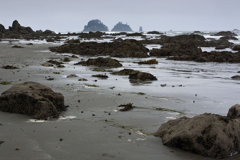
was everywhere, and tide pools cropped up here and there. In the distance, occasionally
emerging from the fog, the Point of Arches, our final obstacle of the day,
could be seen. It looked ominously beautiful and defiant against the gray morning.
 |
| Point of Arches, our destination, is on the far left. |
 |
| Picking our way across the first headland |
We soon passed another headland (4 foot tide), this one a
little trickier to navigate. The tide was out just enough for us to go by, but it required backpacks off, and
Andy hauling me up over a 'pass' in a huge sea rock. A short while later, we
came to the ford of the Ozette River, caramel-colored like all the Olympic coastal
freshwater due to tannins leached from the trees. The Ozette is more like a
medium sized creek, perfectly passable at low tide. During our crossing, it was
thigh deep on me, and knee deep on Andy. We sat on a giant drift-tree on the
opposite site, drying off, snacking on breakfast, and watched seagulls float at
the mouth of the Ozette.
 |
| the second headland |
 |
| where the Ozette meets the Pacific |
 |
| Ozette River ford (photo by AJP) |
The next miles follow a long arc of beach, the footing alternating
between firm-packed sand, deep gravel bars, rolling baby boulders, and deeper
sand. We passed Seafield Creek, our destination for night three, on our way.
About a mile after Seafield, easy travel ceased.
 |
| (photo by AJP) |
 |
| easy beach travel (photo by AJP) |
 |
| jellyman |
 |
| where easy travel stops, just north of Seafield Creek |
I've read several accounts of the backpack from Ozette to
Shi Shi. 'Beautiful' and 'wild' are words frequently used. 'Should be attempted
only by experienced backpackers' is another. Truthfully, from my perspective,
every guidebook and account I've read fails to accurately describe how
challenging the final 2.5-3 miles to Shi Shi really are.
The end of that long arc of beach beyond the Ozette marks
the beginning of the final six headlands required to cross before reaching Shi
Shi- two require a 4 foot tide, and the Point of Arches (just before Shi Shi) requires
a 4.5 foot tide. The traverse begins with a headland characterized by huge
boulders, pieces of the melange cliff
sides that have tumbled down to the ocean. Jumbled, chaotic and sharp, the boulders
are an up and down goat scramble that, in the words of my trail guide,
"require time consuming and strenuous acrobatics." Andy and I made
the mistake of getting too high next to the cliffs- we discovered on the return
journey that staying closer to the water is easier. A small, unsanctioned rope
climb is set up at one point where the boulders are particularly difficult to
pass- I got confused here, thinking we might have stumbled upon the optional
overland trail, which actually appears later. Upon finishing that initiation climb,
I was really displeased to see that the rope I had just put all my faith in was
basically loosely tied to a rock, a rock which looked like it could break away
at any time.
 |
| Cirque du Soleil on rocks |
 |
| sketchy rock anchor (photo by AJP) |
The headland finally relinquished us to the next cove, where
the real optional overland trail appeared. After the first rope climb, I wasn't digging it. Neither was Andy. We arrived almost
immediately at the next headland, also a jumble of large boulders, which is
when the 'reasonable people' and 'Mordor' references came up. Upon rounding
that headland, again, we discovered a small, lovely cove, to immediately,
again, be greeted by another rocky, jumbled headland.
 |
| heading into Mordor |
Progress had crawled to a halt. Bouldering, rope climbing
and picking our careful way among slippery, seaweed-treacherous footing had
slowed us to less than one mile per hour. At this point, both of us were feeling
tired, sweaty and shaky (we made the mistake of skipping lunch), and I was becoming
concerned about the tides. The low tide of 3.0 feet had already passed at
12:49pm, and we were nearing 2pm. The 'safe' window for tides is approximately
two hours on either side of the low.
The slippery, boulder-filled headland dumped us out at the beginning
of the Will Point overland trail. Here, the coastline is impassable, regardless
of the tide level. I was forewarned about the trail and had mentally prepped
for it, but nothing prepares you for the actual 'hiking' of this section to Shi
Shi.
For some people, this trail is probably fun. It wasn't fun,
at all, for Andy and I, at this particular juncture. It's less of a trail and
more of a path taken by some demented bloodhound on a hunt for a bunny rabbit,
trampled into some semblance of a trail by many, many boots. It goes straight
up, traverses the headland, then heads straight down. Its claim to fame is the
fourteen rope-assisted sections of trail where hikers haul themselves, hand
over hand, up the vertical relief, using the occasional well-placed root for an
additional foot or hand hold. On the other side, the trail drops you straight
down, a twisted sort of joke to introduce the unsuspecting backpacker to the
sport of rappelling. The trail spills you briefly into a driftwood filled cove,
then sadistically begins the process all over again. The final descent near the
Point of Arches is extremely steep and requires that you trust your aching
hands and the rope to hold you as hop your way down the mud-slick path.
I kept myself going through a combination of adrenaline, the
fact that I had no choice, and inventing incredibly creative and colorful ways
to swear a blue-streak at the trail. I think I peeled the bark off a few trees.
 |
| What goes up- |
 |
| - must continue up- |
 |
| - must come down. |
It was worth it, however. The final 0.7 miles to Shi Shi
through the Point of Arches is the most spectacular, raw, ominous, and
beautiful piece of coastline I have ever seen. It felt almost prehistoric,
primordial, and nothing about it welcomed my continued presence there. There is
awe in finding places like this that still exist in the world. Maybe it was
just the caloric deficit talking, but I felt very small and very honored to
witness this piece of the world.
Andy and I hadn't seen a single person past our crossing of
the Ozette. Our solitude was short-lived, however, as we arrived to a
ridiculously busy camping scene on Shi Shi. I almost snapped as my sense of
solitude and quiet for the day was abruptly quashed. Apparently, if I had
(again) done my research, I would have discovered that you can, in fact,
drive
to Shi Shi and pay the Makah Reservation
for trailhead parking. There was nothing peaceful about the scene.
Still, we found a spot, trying to give another set of
backpackers their space, and I set about making camp because if I quit moving I
was afraid my body would mutiny on me. Andy laid down on a log and declared,
"You broke me." A few minutes later, in spite of my adrenaline crash
and tired feet, I found myself giggling at the fact that my husband was asleep
and snoring. On a log. I got camp set up, then stuffed both of us in the tent
to chill for a bit.
 |
| broken |
About that time, four campers showed up, walked right
through our site, and set themselves up not 15 feet from us. Later, they would
wash their dishes (with soap) directly in the creek water. I wish I was a
bigger person, but truth is, I thought very uncharitable thoughts about these
men.
 |
| a crowded Shi Shi (photo by AJP) |
At 12:50 am, the campers on the other side of us, across the
creek, decided to set off fireworks in their campfire.
Yeah. I won't be visiting Shi Shi in the summer again.
SHI SHI TO SEAFIELD CREEK
~4 miles
 |
| pleased to be leaving the Shi Shi crowds behind (photo by AJP) |
There was no reason to hurry this morning because the 4.9
foot high tide came in at almost 9 am. We
were packed up by 9:30 and wandering down the beach, away from everyone, back
towards to the Point of Arches. We took our time taking pictures and soaking in
the feel of the place. The light was bluish-silver, the sun desperately trying
to break through the dense marine layer, the sea stacks appearing and
disappearing in the fog like phantoms.


The hike back over Will Point and the Mordor-like headlands
was easier the second time- we were fresh, understood the route, and were
mentally prepped for it. It still took three solid hours to go three miles. We
opted for the optional overland trail this time, and discovered, ironically,
that the back section of it was steeper than anything on the Will Point trail.
Because I'm short, at one point I had a three foot vertical hop down to
negotiate, which mildly freaked Andy out considering he couldn't physically see
me at the time, and my hop caused the rope to shake like a maniac.
"Amanda??!"
"I'm OK! The footing is just for [insert long creative
expletive here] down here. Be prepared to jump a bit!"
 |
| extremely steep & optional (photo by AJP) |
We arrived at Seafield to low tide and a thick, impenetrable
layer of fog. Andy took a nap and I wandered about, stalking sea gulls and
fighting with my water filter, which kept clogging with the tannins.
 |
| marine layer over Seafield |
 |
| nobody but me |
For the first time, in three days, we were completely alone.
Around evening, we made a driftwood fire and sat watching
the marine layer miraculously burn off, treating us to the sight of the sun
meeting the ocean. Two sea otters rolled in the tide and ate dinner on their
backs just off shore. Earlier in the day, a bald eagle had swept through our
campsite, killing a crow not twenty feet from us. We watched the Perseids and
the Milky Way until midnight, when the fog rolled back in.
 |
| sunset at Seafield |
 |
| Milky Way and a Perseid |
 |
| Twin Perseids (faint) |
Bliss.
SEAFIELD CREEK TO OZETTE
~7.5 miles
We woke again to a silver-colored world full of sea sound. We
set off just after 10am, with the high tide, hoping to time our arrival at the
Ozette and the remaining headlands after the tide had gone out enough. We walked in silence, reflected on our thoughts, and watched more sea otters and sea birds play and dine in the surf.


By the time we reached the Ozette, the world was in full
color- the marine layer had finally, completely burned off, and the blue and
green of the ocean was brilliant before us. The Ozette was also much, much
deeper, easily chest-deep on me in the same place we had forded two days before.
We either didn't time our arrival quite right, or the river shifts enough with
the tides that the best place for crossing is ever-changing. I dropped my pack,
stripped my boots off, and played around a bit, feeling my way around for the best
crossing. I finally found a crotch-deep spot on a temporary sand spit near the
mouth of the river that allowed us to cross without having to swim. The
headland immediately after had only barely cleared the 4 foot required tide
level and required some impromptu bouldering. Regardless, we made it in good time
back to the car at Ozette by 2 pm.

This was one of the most mentally challenging, rewarding and
spiritual backpacks I have ever been on. I am not a religious person nor a
church person, but I find a vast, incomprehensible peace in the wilderness I do
not find other places. Normally I seek the alpine, the high, barren, windswept
landscapes of the mountains. Wholly unexpected, this isolated,
wilderness coastline in Washington had that same power for me- we were tolerated in the sense of being only visitors, trespassing temporarily, our lives held to the
shoreline, sandwiched between the power of the ocean and the impassable cliffs,
our footfall dictated by the rhythm of the unforgiving tides.