THREE SISTERS LOOP, 08/08 - 08/11/2010
Three Sisters Wilderness
~48 miles, ~5800 feet elevation change
~48 miles, ~5800 feet elevation change
(So this will be a *retro-active* trail report, but, heck, why not? Why should the new reports have all the fun?
This backpacking trip was, for me, one of the best experiences of last year. A lot went right on this trip, and a lot went very wrong. The trail was both a test and challenge; it is what I would consider my first true solo backpacking experience, for which I am forever grateful and forever humbled. I had been dreaming about this loop for years, and the Sisters, one of my fave places in Oregon, did not disappoint. And, like a good teacher, they threw a lot unexpected my way.)
So backpacking is still relatively new to me. This loop around the Sisters was to be my second solo trip ever, and I am still very much in the process of finding my comfort zone where solo backpacking is concerned. My original plan for this week was to hike the spectacular Spider Meadows-Buck Creek Pass loop in northern Washington's Glacier Peak Wilderness (now on the short-short list of places to go). Unfortunately, plans fell through at the last minute, my week's schedule changed, and I was uninspired to drive 6.5 hours to the trailhead and challenge myself to a 55 mile loop by myself in unfamiliar territory. Since I have always loved the Three Sisters, and I wanted to check the circuit loop around these lovely gals off my bucket list, on Sunday afternoon, me, myself and I (plus one very excited boxer dog, Rocky) left Portland, headed east.
The vast majority of this trip went very, very right, and a couple of things went pretty damn wrong. Unfortunately, with backpacking, you have to experience the stuff going wrong to learn how to anticipate and plan for avoiding those pesky backpacking potholes in the future.
DAY ONE: Pole Creek Trailhead to Golden Lake
~8 miles
I arrived at the Pole Creek TH on Sunday afternoon at 4:00 pm and, after finalizing some last minute details (including having a lovely conversation with two nice rangers just coming off of the trail), was hiking by 4:30. I did not have a really concrete plan for this trip, rather, I just wanted to see how far I could make it each day and play my campsites by ear. Not the best scenario, as I discovered, with my poor dog, but I'll get to that later.
I was originally thinking I might make it all the way to Green Lakes that evening, but eventually decided I didn't really want to do the whole set-up-camp-in-the-dark-acrobatics, so I ended up staying at Golden Lake instead. No settling for second best with that decision. The only people in the basin were a father and his teenage daughter (gotta give a shout-out here for awesome fathers, spending quality time with their children). We chatted a bit, and then I set about pitching camp and getting the Rock-monster and I settled. Only the lake, wind and Rocky's snoring to be heard that night.
I definitely will be going back to the Golden Lake area and exploring for all sorts of little off trail wonders. What a gorgeous basin.
 |
| South Sister from Golden Lake |
DAY TWO: Golden Lake to Mesa Creek
~14.9 miles
Now the views really start. I woke up early, enjoyed the sunrise and broke camp thinking to make it to Eileen Lake- yeah, stupidly ambitious, I know (spoiler alert: didn't make it!), and yet I had the most fabulous day of walking. South Sister was to be my constant companion this day with ever changing views in ever changing light.
 |
| Broken Top from Golden Lake campsite |
The morning passed by in a lovely rhythm of just...walking. One foot in front of the other, no rush, no plans, no set destination.
 |
| South Sister was to be my constant companion today |
 |
| dropping into the Green Lakes basin |
 |
| South Sister from Green Lakes |
Rocky was tired by Moraine Lake (roughly 9ish miles into our day by noon) but still OK by my estimation. I had been concerned about him on this trip because he's a freakin' water hog, and water sources are scarce by my standards for him on this loop. What really did him in, and where the trip started to go downhill: the Wickiup Plains. Sprawling, pumice strewn meadows on South Sister's southwestern flank, stark and bare, yet with a remarkable and interesting beauty, and no water and no shade to speak of anywhere. The pumice here was just too hot for my poor boy- it wasn't actually all that warm in temperature, but, because he's a boxer, he's extremely prone to overheating (which is why I was ALWAYS carrying at least 3 liters of water on this trip). By the time I realized how hot and tired he actually was, it was too late to turn around.

 |
| tired feet at Moraine Lake |
 |
| South Sister from the Wickiup Plains |
Lesson number one: My dog is picky. He will drink out of streams, lay in streams, and soak his feet in streams. He loves mountain snow cones. But if I carry pounds of water on my back for him, he won't drink it. Why? Because now it's yucky and warm. Brat.
We made it that night to Mesa Creek, and what yummy, cold and delicious water it was. Rocky was so tired that he basically deigned to eat and was done. Micro-balled and don't talk to me. If he had been a mule, no amount of flogging would have gotten him up and moving. Ce' la vie. I put him in the tent by 5 pm, and he made no effort to get up or anything likewise until 8:30 the next morning.
Taking stock of myself: I had the beginnings of a lovely blister on my right heel, but it wasn't (as of yet) unmanageable; I was footsore and stinky, but still in good spirits. I relaxed in the late afternoon sun, ate Snickers bars (trail food of champions) and enjoyed the million lupine bordering Mesa Creek. The plan was changing: I had read about a use path that turns off the Pacific Crest Trail (PCT) and climbs the saddle between Middle and North Sisters to Camp Lake. I would attempt to find that use-path to cut some mileage off my trip and spare Rocky some walking. The scenery thus far had been phenomenal, I was feeling far from scenery-cheated, and I was absolutely falling in love with solo backpacking. That night I even got to see some of the exquisite Perseids, which I make a mission to see every year that I can.
 |
| giant lupine at Mesa Creek |
DAY THREE: Mesa Creek to Minnie Scott Springs
~12.9 miles
Lesson number two: Don't count on finding use paths. They have a way of not appearing.
Lesson number three: Don't get cocky about how your blister isn't too bad. Like gremlins in water, they tend to multiply.
 |
| Middle Sister, my day two companion |
 |
| shoooooot, wish I'd stayed here last night |
The weather this day cooled dramatically, threatening rain and spooky fog at times. It was also some of the best scenery of the trip, traipsing along the PCT. South Sister was saying her farewells, Middle Sister was the prominent player of the day and North Sister was stubbornly hiding in the clouds.
 |
| Middle & South Sisters from the PCT |
 |
| Obsidian area |
Rocky was very tired by now, and I was becoming concerned about my ambitious "Three Sisters Backpack" and the long mileage on him; however, as the pig in Toy Story puts it, "Nope, too late, gotta go round the horn!" One of the humbling experiences about wilderness is that whatever you get yourself into, you've only got yourself to get yourself out of it. Granted this wasn't the worst situation in the world, but I was concerned. At 75lbs, he's half my weight and there was no way I could carry him out if he completely bonked on me.
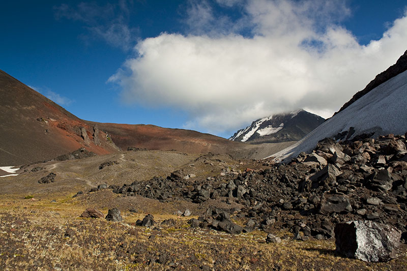
Regardless, the PCT in this area is spectacular. Beyond the Obsidian area, the evening light around North Sister and Opie Dilldock pass mesmerized me, tired as I was. I had put booties on Rocky since before Obsidian, and he clearly wasn't pleased with them, walking like a deranged duck the entire time. The problem came just near Opie Dilldock- obsessed with snow but still refusing to drink if I offered him water, Rocky slipped on a snowfield and while I didn't know it at the time, twisted his front paw badly. We made it to Minnie Scott Springs, where I set up camp and stuck him in the tent (man down, again, he was beat) and discovered, as I had been worried about all day, that my blisters had multiplied. In my concern about my dog, I had neglected my feet, and I was gonna pay for that.
 |
| Collier Cone is that pointy thing I sure as hell am NOT climbing now. We're just beyond Opie Dilldock pass, 6870 ft. and we're BEAT. Another mile to go before we end an almost 13 mile day. |
 |
| wow |
 |
| this is the look of the trail, kicking my ass |
DAY FOUR: Minnie Scott Springs to Pole Creek Trailhead
~12.2 miles
After a night of watching lightning play in the distance, the day dawned bright and surprisingly chilly. Neither Rocky nor I were all that interested in moving, but at this point I figured I really just needed to get both he and I home. What dismayed me was a swollen front paw; I was shocked. It wasn't disfigured, but along with the many hot spots on his feet, he was grumpy and footsore. Heck, I was grumpy and footsore. So now I was worried. And at the time, the only thing I could figure to do was to get us both home.
 |
| one of nine reasons why today was going to end up a death march |
So, armed with tons of moleskin, we set out. Until South Matthieu lake, we weren't so bad. Rocky actually rallied and fell into step beside me, and I started to think this day wouldn't be so critical after all.
Lesson number four: If you suspect the day is going to be a death march, it is probably going to end up as a death march.
The scenery held until South Matthieu lake, after which I knew from Allison Wildman's report that it was basically going to be all boring, Central Oregon forest walking. And hallelujah for that report- she actually helped me avoid visiting Yapoah Lake, which by the time I got to that area, I really, really, really did NOT want to do.
Lesson number five: TRUST signage in the Three Sisters. It's pretty good. We're not talking backcountry Alaska here. If you see a trail jutting off to the right or left, and it seems like it should go where you want to go but doesn't say it's where you want to go, just stick with going forward. You're probably right.
 |
| why the scenery held: one of the most beautiful alpine meadows I have ever seen |
 |
| looking north on the PCT |
 |
| North Sister from near South Matthieu lake |
Lesson number five: TRUST signage in the Three Sisters. It's pretty good. We're not talking backcountry Alaska here. If you see a trail jutting off to the right or left, and it seems like it should go where you want to go but doesn't say it's where you want to go, just stick with going forward. You're probably right.
By the time I hit Alder Creek, with ~5 miles left to the trailhead, my feet were in agony despite loads of moleskin and band aids.
 |
| he's soooo tired and we have five more miles to go |
Lesson number six: Chacos are THE BEST SHOES EVER.
Lesson number seven: No matter how awesome Chacos are, little tiny pumice rocks and sand WILL find their way into any nook and cranny of your foot that they can.
 |
| I {heart} chacos |
I arrived at the car by 4 pm, and threw my shoes away in a trashcan at trailhead. Good. Riddens. Rocky was down, down, down and slept the entire car ride home to Portland and has basically been sleeping the last 2 days. However, with much antiseptic cream and Neosporin, he's back to being a happy, bean-wagging, no longer so footsore, healthy dog. My blisters still suck. But what a phenomenal area. And overall, a really, really damn good trip.


